Water
Getting water off a sloping Piedmont lot
The most common landscape complaint in Sandy Springs, and the one most often solved with the wrong tool. The distinction that matters is between water on the ground and water in it.
Why the water is there
It is arithmetic rather than a soil defect. The USDA series description for Cecil, the reference soil across the Georgia Piedmont, calls the soil well drained with moderately high saturated conductivity and records surface runoff as medium. The Metro North Georgia Water Planning District puts the working figure for clay absorption at about half an inch of water per hour. Atlanta summer storms are convective and short, and they routinely deliver more than that in fifteen or twenty minutes.
So the water is not sitting because the soil is bad. It is sitting because it arrived faster than any soil could take it, and then had nowhere to go. On a lot that falls from a street at the top to a creek at the bottom, that surplus runs the whole length of the property, gathering volume from the driveway, the roof, the neighboring lot and every compacted area on the way down.
Telling the two problems apart
The test is time, not depth. Water that stands after a storm and is gone within a day is surface runoff that had nowhere to go. That wants grading and conveyance: a swale, a regrade, a collection point, a pipe with capacity. Ground that stays soft for days after the rain has stopped is saturated, and that wants subsurface interception: a properly built French drain, or a change to what is planted there.
A great many Sandy Springs properties have both, in different places, and the mistake is to buy a French drain for a problem that is entirely on the surface. A four-inch perforated pipe moves a modest flow. It cannot absorb the runoff from a driveway during an Atlanta thunderstorm, and installing it in that role guarantees an unhappy homeowner.
What each fix does
- Regrading. The cheapest and most under-used option. Changing the shape of the ground so water leaves instead of collecting fixes more yards than any pipe does.
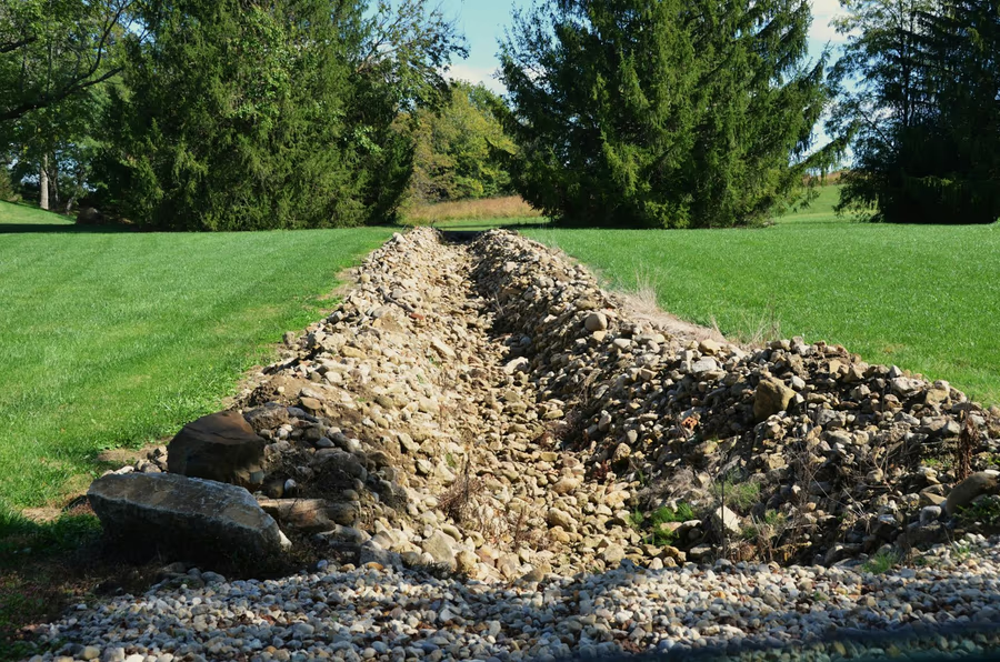
- Swales and dry creek beds. A shallow shaped channel across or along the slope, vegetated or stone-lined, that carries large volumes slowly. On a wooded lot a dry creek bed does the hydraulic work and reads as part of the garden the rest of the year.
- Catch basins and solid pipe. Where volume is genuinely high, a grated inlet at the low point and a solid pipe to a discharge point. Clean-outs at direction changes mean the run can be jetted rather than dug up.
- French drains. A graded trench, washed stone, a perforated pipe, and a filter fabric wrap so clay fines do not migrate into the aggregate. Without the wrap it is a slow-motion failure.
- Downspout collection. Roof water is the largest single input on most lots and the easiest to move. Taking it well away from the foundation in solid pipe is cheap and disproportionately effective.
- Slope stabilisation. Matting, deep-rooted planting and coarse mulch on any bare grade. Bare Piedmont clay sheds soil in the first storm after it is exposed.
Choosing where the water ends up
Every drain has to finish somewhere, and on a sloping wooded lot that decision governs everything upstream of it. The outlet has to be lower than every inlet with continuous fall the whole way, so fixing it first sets the depth of the trench, the route it takes and, frequently, whether the design works at all. Choosing it last is how a trench gets dug twice.
A destination has to do three things. It has to be low enough to run by gravity. It has to be able to take the volume, which on a Piedmont lot means a real storm rather than an average one. And it has to release the water somewhere it can spread and slow down, because concentrated flow arriving at one point is how banks get cut back and gullies start. Discharging into a bed of washed stone, onto a stabilised slope planted through matting, or into a shaped dry creek bed all do that. A bare pipe end pointing at a soft bank does not.
What not to do
- Do not send it next door. A regrade that solves your low corner by directing flow onto a neighbor has not solved anything, it has moved the problem across the boundary and made it someone else's.
- Do not point a pipe at a creek bank. Concentrated flow at a single point takes the bank apart a little at a time, and the ground lost that way does not come back.
- Do not fill a stone trench without fabric. Clay fines will find it.
- Do not build over the flow path. A patio, a wall or a new bed placed across an uncontrolled drainage route is a repair with a date on it.
Where the grade itself is doing the damage, the answer is usually structural rather than hydraulic. See the wall types guide, and what a drainage scope covers.
Sources
USDA NRCS Official Series Description for the Cecil series. Metro North Georgia Water Planning District irrigation guidance for the clay absorption figure. NOAA 1991 to 2020 climate normals for Atlanta Hartsfield-Jackson.